I-73 Location Study
In late March 2007, the Federal Highway Administration (FHWA) issued a Record of Decision (ROD) authorizing VDOT to begin design, purchase right of way and eventually construct I-73, depending on funding. VDOT is now working to prioritize segments from which to begin initial design work. FHWA also included a table of measures to mitigate and minimize impacts of construction.
How we got here:
In 1991, Congress identified the need for a north-south corridor from north of Detroit to near Charleston, S.C. In Virginia, the I-73 corridor (which was about 5-7 miles wide) generally follows the Route 460 corridor from West Virginia to the Smart Road in Montgomery County to I-81 to Roanoke. It then turns south along I-581 to Route 220 in order to connect Roanoke to Greensboro, N.C.
The Purpose and Need:
NOTE: The only portion of I-73 under study in Virginia is from I-81 to North Carolina.
In Virginia, an I-73 Location Study began in 1997 with work on a Draft Environmental Impact Statement to document the section of the corridor from I-81 heading south to the North Carolina state line. As part of the study, a statement of Purpose and Need was developed. Purpose and Need is similar to the first chapter of a book. It is a document that states existing problems and identifies needs of the existing transportation system. For I-73, the Purpose and Need chapter of the DEIS includes these statements:
- The need for improved transportation facilities for goods movement, which links the port of Charleston, S.C., with Detroit and Sault Saint Marie, Mich.
- The need for an effective and efficient roadway, which facilitates interstate travel between Michigan, Ohio, West Virginia, Virginia, and North and South Carolina.
- The need for a safe and direct transportation link for business trucking between North Carolina's Piedmont Triangle and the Roanoke Valley's I-581 and I-81 corridors.
- The need for an interstate transportation facility to foster planned economic development between southwestern Virginia and the Piedmont Triad regions and between Virginia communities from the City of Roanoke to the North Carolina state line.
The Purpose and Need also identified several safety concerns in the I-73 corridor:
- The high percentage of truck traffic on U.S. Route 220.
- The designation of U.S. 220 as a Surface Transportation Assistance Act (STAA) roadway that allows for oversized trucks on a roadway with identified sight distance problems.
- The high accident rates on U.S. Route 220 between Route 419 and the North Carolina border.
- Steep road grades on portions of U.S. Route 220.
- The number of crossovers with no turn lanes or with turn lanes in only one direction on U.S. Route 220, which increases the number of accidents.
- Access to the Blue Ridge Parkway on-ramps from the south and to other area historic and natural resources.
Additionally, the Purpose and Need stated the specific objectives for the I-73 Location Study:
- Identify the location of a "high priority" link in the National Highway System.
- Reduce conflicts between local traffic and truck traffic in U.S. Route 220 and improve transportation safety in the U.S. Route 220 corridor between I-581 and North Carolina.
- Enhance goods movement by providing efficient transportation for truck traffic by separating existing and projected U.S. Route 220 truck volumes from local traffic.
- Improve transportation infrastructure between North Carolina's Piedmont Triad, Virginia's West Piedmont Planning District Commission (PDC) and Roanoke Valley Alleghany Regional Planning Commission.
- Support local economic initiatives and existing and planned business and industry.
- Enhance mobility and access through southwestern Virginia and the national high priority corridor.
Where should I-73 go?

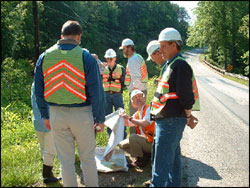
VDOT crews gather environmental information
as part of the I-73 location study
This is the question VDOT asked citizens in January 1998 during a series of public participation meetings. A draft Purpose and Need statement was available at the meetings. Hundreds of people turned out to give their opinions on the possibility of a new interstate, as well as offer suggestions on where it should go, what it should be close to and what it should avoid.
The I-73 Study Team took this input and began to develop several options, or alternatives, for the I-73 Location Study. Dozens of possible alternatives were identified. VDOT held another round of public participation meetings to show maps of the alternatives and ask citizens what they thought. Among the alternatives were several locations for building a new interstate, an alternative called Transportation System Management that consisted of lower cost improvements to existing Route 220, and an option not to build a new interstate called “no build.” (For more information on the alternatives presented, click here to read the I-73 newsletter from November 2000)
After the Draft Environmental Impact Statement was completed, which documented each of the alternatives under consideration, VDOT held public hearings throughout the corridor so that interested people could comment on the contents of the DEIS and formally register their opinions about I-73.
"Build" It:
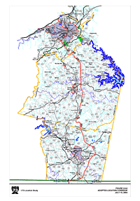
In May 2001, the Commonwealth Transportation Board voted to build I-73 and chose a location. At that time, I-73 overlapped I-581 in Roanoke and continued to Elm Avenue where it turned southwest over Windy Gap Mountain before entering Franklin County. Once in Franklin County, the location turned nearly due south to run roughly parallel to Route 220, passing to the east of Rocky Mount. I-73 briefly connected again with Route 220 in southern Franklin County before turning southeast to curve around the eastern side of Martinsville and then connects with Route 220 at the North Carolina line. A month later, the CTB revised the routing in Franklin and Henry Counties.
Historic Changes:
 In November 2002, The Keeper of the National Register of Historic Places determined that the “Southeast Roanoke Neighborhood” in Roanoke was eligible for historic designation. As a result, the Federal Highway Administration informed VDOT that another section of I-73 through Roanoke must be chosen to avoid the neighborhood. Federal regulations prohibit the development of federally funded projects through historic sites if other feasible alternatives exist. Although the I-73 DEIS documented historic sites, at the time of its completion, the Roanoke neighborhood was not assumed to be historically significant. A local group challenged this assumption, and the issue was presented to the Keeper of the National Register for a final determination.
In 2004, VDOT held two citizen information meetings on the need to change the corridor, and the Commonwealth Transportation Board voted to alter a small section of the routing for I-73. The new section, after overlapping I-581 to Elm Avenue, then follows Route 220 through Roanoke and into southern Roanoke County before turning southeast following Route 687 into Franklin County, where it connects with the route previously selected.
For a more detailed view of the route for I-73, click on the map to the right.
In late November 2006, VDOT completed the Final Environmental Impact Statement (FEIS) and submitted the document to FHWA for consideration of a Record of Decision (ROD). FHWA issued a ROD in late March 2007.


